Bank Stabilization and Riparian Restoration

Two sites on lower Cahto Creek and one on lower Streeter Creek will be treated under this grant. Sites were chosen based on field observations, landowner cooperation, the amount of sediment pollution prevented and the importance of reaches to threatened native salmon and steelhead. Complete details of the site selection process can be found in the Tenmile Creek Watershed Conservation and Restoration Action Plan.
Stillwater Sciences developed 100% engineered designs for the three bioengineering projects. All include layers of living willow that will knit the structures together, improve shade to help cool water temperatures, and provide excellent cover for adult and juvenile salmon and steelhead. At the Hogan and Mueller sites on lower Cahto Creek, non-native Himalaya blackberry thickets will be removed and native tree riparian gallery forests will be established in their place.
Hogan Property – Lower Cahto Creek

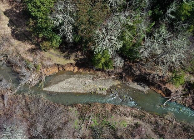
The 165-foot length of eroding bank on Cahto Creek on the Hogan property will be treated with three boulder deflectors with large wood and living willow embedded. A total of 12 logs will be built-in to the structures, with rootwads extending into the stream at the base of each project. Living willow will be embedded in layers of aggregate within the structure, and watered immediately upon installation and irrigation will be maintained until rain fall is sufficient. Invasive Himalaya blackberry on the west bank will be removed and a native tree gallery forest established to replace it (see Cahto Creek Gallery Forest Revegetation Plan - Hogan Property.)

Stillwater 100% Design – Hogan Cahto Creek site.

Partner Dennis Hogan at right with ERRP contractors (r to l) Logan Edwards, Steve Brown and Hugh McGee.
ERRP Partners: Dennis and Mary Beth Hogan have been ideal partners with the Eel River Recovery Project, participating not on in this riparian restoration project, but also on forest health. Dennis has dug a well, built a pump shed, and will deliver irrigation water for both the bioengineering project and his riparian gallery forest restoration. He has been growing seedlings and saplings in his greenhouse to prepare for his gallery forest restoration project. Dennis is a retired Laytonville High School teacher and LHS students will get hands-on restoration experiences at his place.
Mulligan Property – Lower Cahto Creek


Stillwater 100% Design – Mueller Cahto Creek site
The Mueller site is 135 ft long, with little to no riparian vegetation on the exposed 11-foot high bank that is nearly vertical. Due to the high flow velocities, sharp bend, and bank composed of fine-grained erosive soil, a restoration approach that uses large wood and boulder features in combination with bioengineered coir lifts is proposed for this site. A total of 17 logs will be embedded in the bioengineering project, including at the base with rootwads extending into the stream to improve scour and habitat complexity. A boulder base will provide the foundation for two large willow lifts that use coconut fiber (coir) to wrap stream aggregate that is the medium for thousands of willow branches that will create a willow wall when irrigated.

Mueller family (l to r) Martin, Sally, Raechal, Steve Brown, and Miles.
ERRP Partners: The Mueller family acquired a parcel after ERRP had already secured funding for the 319h bioengineering project at their new place, and they couldn’t be more thrilled. Martin and Sally moved down from Portland to retire in northern Mendocino and they have been joined by their son Miles and wife Rachael. They want to farm organically, but are also interested in accelerating the ecological recovery of Cahto Creek on their property. They also have a plan to remove invasive species and re-establish a native tree gallery forest (see Cahto Creek Gallery Forest Revegetation Plan - Mueller Property). The Mueller family is also participating in the CALFIRE grant that ERRP has for Tenmile Creek.
Streeter Creek – Black Oak Ranch


The Streeter Creek Project site is located approximately 500 ft upstream of the confluence of Tenmile Creek and contains a sharp bend in the channel that is causing severe erosion. Site length is 165 ft and the average height of the failing bank is 16 ft. A coir-wrapped living willow lift with a boulder base will span the area of the failure, and boulder wing deflectors will be constructed at the upstream and downstream extent of the project. Sixteen 16 pieces of large wood will be embedded in the structure, including rootwads that will extend out from the base to scour a deeper pool and to provide fish habitat complexity. Native grasses will be planted at the top of the bank in areas disturbed by project construction and riparian trees planted along the top of the bank.

Stillwater 100% Design – Streeter Creek site

(l to r) Hugh McGee, Bob Barsotti of BOR, Logan Edwards and Rebecca Garwood of CDFW.
ERRP Partner: The Black Oak Ranch is a key partner with ERRP, participating in this 319h project and also on planning and permitting a large-scale water conservation project that will allow forbearance of water withdrawal from Streeter Creek and Tenmile Creek during seasons of low flow. BOR is also part of the ERRP Tenmile Creek Forest Health Project funded by CALFIRE, although only for the purpose of CEQA planning. BOR is a Harmony-based enterprise and has promoted restoration of the environment since the inception of the collective in 1980