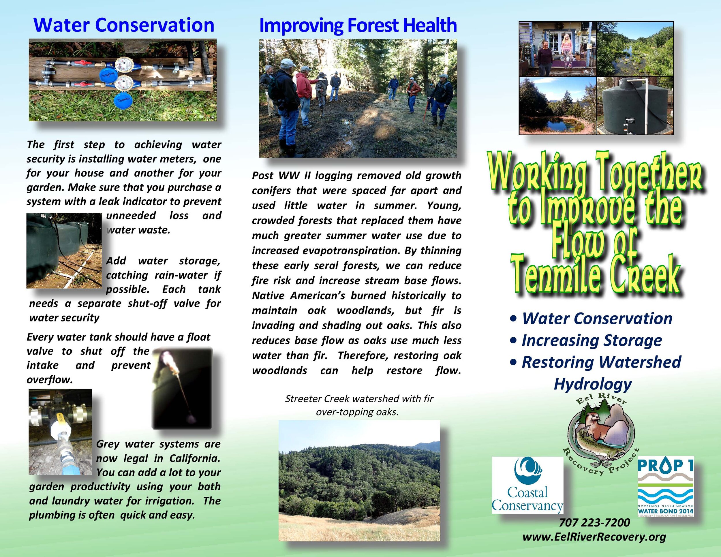
Water Conservation in Tenmile Creek
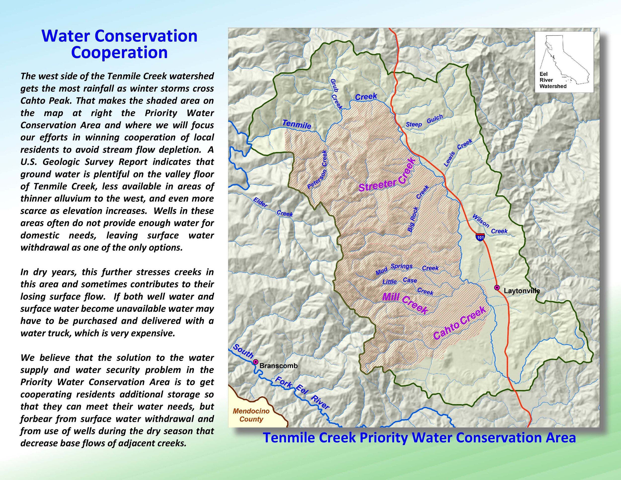
Historically Tenmile Creek had perennial cold-water flow and supported coho salmon juvenile rearing in reaches of the main stream, as well as in several of its tributaries. Now, in dry years, the upper and middle reaches of Tenmile Creek and some major tributaries become disconnected or lose surface flow altogether. The community wants to see stream-flow restored. The Tenmile Creek pilot project focuses on Streeter and Big Rock creeks, which are on the opposite side of Cahto Peak from Elder Creek. The Elder Creek watershed is intact old-growth forest with no history of recent human disturbance, so the creek serves as a control.
Thomas Gast & Associates, Environmental Consultants (TGAEC) collected flow data in 2018 and 2019 for Streeter Creek, Big Rock Creek, Tenmile Creek above its convergence with the South Fork and in its the middle reach at a former U.S. Geological Survey gage location. Flow data collected by USGS for Elder Creek are used for comparison. TGAEC is analyzing patterns in flow data using the U.S. Environmental Protection Agency model called VELMA (Visualizing Ecosystem Land Management Assessments) to discern changes in Streeter and Big Rock creeks from historic flow levels. The difference between current and historic flows will be used to calculate how much water storage would be needed to allow forbearance of water use in order to restore surface flow.
During the course of the TGAEC study, it has become apparent that factors other than water diversion are driving the reduction of baseflow and departure from historic conditions. One factor is the presence of early to mid-seral forests that have extremely high rates of evapotranspiration. Old growth logging after WW II gave rise to young forests with much higher tree density. The trees’ water use peaks when the forest reaches 40-60 years of age. Also, oak forests use very little water in summer. But Douglas fir is overtaking oaks in the Streeter Creek watershed, which can lead to higher evapotranspiration and reduction in stream baseflow. Therefore, implementing forest health in Streeter Creek may help restore flows.

This photo shows Tenmile Creek at the Black Oak Ranch running dry in August 2018. This is not the historic condition and the community wants to work together to restore perennial flows and a stream that supports abundant salmon and steelhead runs.

Hollie talking to Bob Barsotti (l) of Black Oak Ranch about conservation.
ERRP is adopting a strategy of forbearance devised by Sanctuary Forest that won cooperation for from upper Mattole land owners and restored summer surface flows there. Hollie Hall leads efforts to identify opportunities to implement forbearance in Streeter and Big Rock creeks, which entails determining additional water storage needs and mechanisms for grant funding.
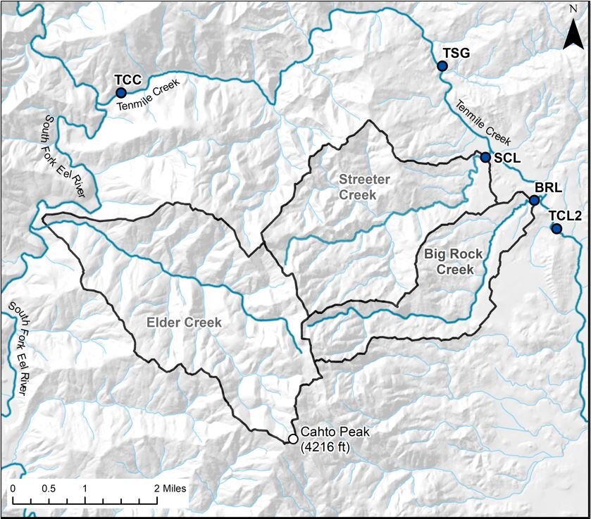
The location of TGAEC flow measurement stations in 2018 and 2019: Big Rock Creek (BRL), Streeter Creek (SCL), Tenmile Creek upstream of Big Rock Creek at the old USGS gage site (TCL2), Tenmile Creek below Sulphur Gulch (TSG) and lower Tenmile Creek just above the South Fork (TCC). Beaver activity at TCL2 made it unsuitable for summer flow measurement so 2019 measurements were taken at TSG.
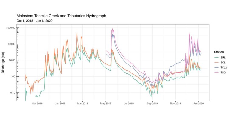
This chart shows flow data comparison from August 2018 through December 15, 2019 from Big Rock Creek (BRL), Streeter Creek (SCL), Tenmile Creek upstream of Big Rock Creek (TCL2) and Tenmile Creek below Sulphur Gulch. Big Rock and Streeter creeks lost surface flow in 2018, but not in 2019.

Flow comparison of Big Rock, Streeter and Elder Creek for the ascending hydrograph from October 2018 to February 2019, which is the first portion of the 2019 Water Year. After peaks, Elder’s flow descends slowly, while Streeter and Big Rock creeks descend much more rapidly, indicating hydrologic alteration of the watershed related to land management.
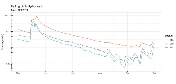
A flow data comparison from May 2019 to October 2019 of Big Rock Creek, Streeter Creek and control stream Elder Creek do not indicate short-term flow reductions or disruptions characteristic of agricultural diversions for either Big Rock or Streeter.

A map of bedrock geology of the western Tenmile Creek basin shows a major contact in the middle of the Streeter Creek and Big Rock Creek watersheds that indicates a transition to the Central-belt Mélange Terrain. This is significant because these rocks have less water holding capacity than the Franciscan Formation, which contains argillite sandstone that fracture and capture water. Rainfall is greatest in the upper watersheds of Streeter and Big Rock, which are in the Franciscan Formation, so their water storage is still considerable.

TGAEC created this map of forest age for the Elder, Streeter and Big Rock Creek watersheds. It shows that upper Streeter Creek has an average forest age of 48-68 years old, which is the stage during which peak evapotranspiration and water use occurs.
Click on image below to view / download the brochure.